-
Download:
My Results |
All BMPs
Precision Agriculture
 Using GPS maps for more precise nutrient application. Photo courtesy of University of Wisconsin Extension.
Practice Type: Management
Landuse/Agriculture Type: Row Crop
Climatic Zones: Temperate, Semiarid, Tropical
Regions: North America, South Asia, Europe
Pollutants Treated: Nitrogen, Phosphorus, Sediment
N Efficiency1: 3.5%
Description: Precision agriculture can also be referred to as Precision Farming, Satellite Farming, or Site Specific Crop Management (SSCM). Precision agriculture is a management system that takes into account the spatial and temporal variability within the field. Using GPS and sensor technologies, producers can map variability in slope, soil type, soil moisture, crop yield, nutrient levels, organic matter, etc. in order to create management zones. Within management zones, crop management can be tailored to suit the specific needs of that zone in a way that maximizes yields and minimize inputs (water, pesticides and nutrients). Precision agriculture is enabled by technologies like crop yield monitors, GPS-equipped combines, variable rate technologies (e.g. seeders, sprayers, etc.), and real-time sensors to measure variables like moisture and chlorophyll levels, hyper-spectral aerial and satellite imagery, and other geospatial tools. 2
Implementation Considerations: Precision agriculture encompasses a suite of high-tech tools, many of which are relatively inexpensive. Furthermore, a USDA study estimates that some precision agriculture tools, such as GPS guidance systems, pay for themselves within 2-3 years by way of reduced fuel costs, reduced fertilizer costs and higher yields.
Scalable to small farms? No
Scaling Considerations: Requires geospatial mapping tools and the capacity to modify crop inputs to specific locations within fields. More applicable to large acreage management.
1 "Documentation: Source Data, BMP Effectiveness Values." Chesapeake Assessment Scenario Tool. Web. 2013. http://casttool.org/Documentation.aspx .
2 Estimates of County-level Nitrogen and Phosphorus Data for Use in Modeling Pollutant Reduction Documentation for Scenario Builder Version 2.2." Chesapeake Bay. Dec. 2010. Web. May 2013. http://archive.chesapeakebay.net/pubs/SB_V22_Final_12_31_2010.pdf.
Rangeland rehabilitation
Category: Grazing Management, Erosion Control
Practice Type: Management
Landuse/Agriculture Type: Pasture
Climatic Zones: Semiarid
Regions: South Africa
Pollutants Treated: Nitrogen, Phosphorus, Sediment
Description: Rangeland rehabilitation is a practice in which perennial grasses are used to rehabilitate the footslopes in a semi-arid region on a clay loam soil. Different techniques including mechanical (e.g. ripper, dyker plough) as well as biological (e.g. stone dams, loose dams) can be used to rehabilitate a totally degraded area. Different combinations can also be used (e.g. ripper with seed and ripper without seed) to see if there is a natural seed bank left. The purpose is to get palatable vegetation back in the area for animal consumption. Rangeland rehabilitation helps to minimize erosion and decrease runoff. 1
Scalable to small farms? Yes
1 Lötter, Lianda, Liesl D. Stronkhorst, and Dr Hendrik J. Smith. "Sustainable Land Management Practices of South Africa." World Overview of Conservation Approaches and Technologies (WOCAT). Dec. 2009. Web. June 2014..
Practice Type: Management
Landuse/Agriculture Type: Pasture
Climatic Zones: Semiarid
Regions: South Africa
Pollutants Treated: Nitrogen, Phosphorus, Sediment
Description: Rangeland rehabilitation is a practice in which perennial grasses are used to rehabilitate the footslopes in a semi-arid region on a clay loam soil. Different techniques including mechanical (e.g. ripper, dyker plough) as well as biological (e.g. stone dams, loose dams) can be used to rehabilitate a totally degraded area. Different combinations can also be used (e.g. ripper with seed and ripper without seed) to see if there is a natural seed bank left. The purpose is to get palatable vegetation back in the area for animal consumption. Rangeland rehabilitation helps to minimize erosion and decrease runoff. 1
Scalable to small farms? Yes
1 Lötter, Lianda, Liesl D. Stronkhorst, and Dr Hendrik J. Smith. "Sustainable Land Management Practices of South Africa." World Overview of Conservation Approaches and Technologies (WOCAT). Dec. 2009. Web. June 2014.
Reduced Tillage
Category: Erosion Control
Practice Type: Management
Landuse/Agriculture Type: Row Crop, Small Grains
Climatic Zones: Temperate, Semiarid, Tropical
Regions: North America, Europe, Africa, Asia
Pollutants Treated: Nitrogen, Phosphorus, Sediment
Description: Reduced tillage systems leave between 15% and 30% crop residue cover to prevent erosion and conserve soil moisture. Tillage is reduced by replacing some tillage operations for weed control with herbicide applications or by using tillage equipment that helps maintain a good residue cover. 1
Implementation Considerations: Reduced tillage systems save time and energy, and costs are usually similar to or lower than those for conventional tillage systems. Adoption of effective reduced tillage calls for flexible approach to crop management. Seasonal conditions will alter soil moisture content, weed growth, amount of crop stubble and time of sowing. As a result, grazing strategy, the herbicide spray programme, and cultivation practice may need to be altered from year to year to account for these changes.
Scalable to small farms? Yes
1 "Beneficial Management Practices: Environmental Manual for Crop Producers in Alberta." Alberta Agriculture and Rural Development. 2004. Web. Apr. 2014. http://www1.agric.gov.ab.ca/$department/deptdocs.nsf/all/agdex9483/$file/100_25-1.pdf?OpenElement .
Ridge Tillage (Conservation Tillage)
 Ridge till farmer in Pocahontas County, Iowa, saves input costs as well as soil with a ridge-till planting system. Photographer: Lynn Betts. Photo Courtsey of USDA NRCS.
Practice Type: Management
Landuse/Agriculture Type: Row Crop
Climatic Zones: Temperate, Semiarid, Tropical
Regions: North America, Europe
Pollutants Treated: Nitrogen, Phosphorus, Sediment
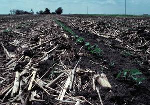
Description: Ridge tillage is a conservation tillage system where crops are grown on ridges built during the cultivation of the previous year's crop. The crop residues are left undisturbed from harvesting to planting, preventing erosion over the fall and winter months. Most residues are swept into the valleys between ridges, leaving the ridges with fewer residues. As a result ridges create an optimal seed bed. In addition, because of their elevation, the ridges drain faster and warm up more quickly in the spring than do non-ridged surfaces. Therefore earlier planting is possible. Ridge tillage helps reduce the use of in-crop herbicide inputs and ammonia volatilization. 1
Implementation Considerations: A special planter or planter attachment that can plant on ridges is required. Wheel and tire widths of fertilizer spreaders, tractors, and combines need to be adjusted to run in the valley between the ridges. End rows can present a problem to equipment when turning because of the ridged surface. Most farmers opt to use no-till or mulch-till on the end rows.
Scalable to small farms? Yes
Scaling Considerations: See FAO website for South China: http://www.fao.org/docrep/x5670e/x5670e06.htm May be appropriate in specific conditions where the soils are wet and cool in the spring and the practice would enhance crop productivity.
1 "Best Management Practices, Today's Agriculture: A Responsible Legacy." Nutrient Best Management Practices. Web. Aug. 2013. http://dda.delaware.gov/nutrients/D17762BestMgmtbklt.pdf .
Riparian Forest Buffers
Category: Conservation Buffers
Practice Type: Structural
Landuse/Agriculture Type: Row Crop, Pasture, Fodder, Rice, Small Grains
Climatic Zones: Temperate, Semiarid, Tropical
Regions: North America, South Asia, Europe
Pollutants Treated: Nitrogen, Phosphorus, Sediment
N Efficiency1: 19-65%
P Efficiency1: 30-45%
S Efficiency1: 40-60%
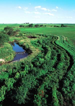
Description: Riparian forest buffers are linear vegetated areas with well-developed root systems, an organic surface layer, and understory vegetation adjacent to open water. They are generally in locations where runoff water leaves a field, with the intention that sediment, organic material, nutrients and chemicals can be filtered from the runoff water. Buffer vegetation can improve soil aeration, lessen water quality degradation by nutrient removal in the root zone by plant uptake and sorption to soil, and provide wildlife habitat. The efficiency of buffer zones in removing suspended solids and nutrients is affected by the width of the zone, gradient of the drained field, soil type and particularly by the variety and density of zone vegetation.2
Implementation Considerations: For either grass or tree buffers, width is the most important criteria. 10 m width should be the goal. If land is limited, smaller width buffers are better than no buffer even though they have reduced efficiency. Establishment of buffers requires taking land out of crop production,but well planned buffers can provide opportunities for agroforestry for fodder or timber; Cost of establishing forest buffers can be high but maintenance costs are usually low. Over the long term, buffers are very cost effective practices in terms of dollars per pound of nutrient reduced.
Scalable to small farms? Yes
Scaling Considerations: Protected vegetated zones that are harvested for fodder or timber have the potential to increase biomass compared to overgrazed streamside pastures.
1 "Documentation: Source Data, BMP Effectiveness Values." Chesapeake Assessment Scenario Tool. Web. 2013. http://casttool.org/Documentation.aspx .
2 Estimates of County-level Nitrogen and Phosphorus Data for Use in Modeling Pollutant Reduction Documentation for Scenario Builder Version 2.2." Chesapeake Bay. Dec. 2010. Web. May 2013. http://archive.chesapeakebay.net/pubs/SB_V22_Final_12_31_2010.pdf.


